
When we arrived in Quito, we were very fortunate to be staying with the mother (Elsa) of our close friend and fellow Adventure Gang member Gabby. Fortunately for us, Elsa is a magnificent host and has the same thirst for fun as her daughter.
Day 1 – Mitad del Mundo.
During our first couple of days in Quito, Elsa was out of town, so we caught a local bus 30 minutes North, to the official ‘Mitad del Mundo’ (Centre of the World) and spent a relaxing afternoon at the monument site, sampling the various experiments in the museum and planetarium, the mock ancient village, chocolate museum and middle of the world train (total cost US$7.50p.p.). The monument was constructed at great expense on the site by the Ecuadorian government, after a bunch of French scientists pronounced it as being the precise spot of 0 degrees latitude in the late 19th Century.

It turns out that it’s actually about 200m South of the true 0 degrees spot, according to the GPS on Jon’s phone, so after we left there, we set about walking to the exact spot, only to find that there is a much smaller, less ‘touristy’ (if there is such a word) and frankly more interesting, alternative monument and a small museum in the correct spot. So we took a quick photo at the correct spot just for the record. Ironically, the pre-Inca residents of Quito had somehow managed to get the correct location some 1200 years before modern scientists managed to mess it up!

Day 2 – ‘Not’ TeleferiQo
We bussed 15 minutes south to the bottom of TeleferiQo. This is a cable car system which runs up the side of Volcun Pichincha to a height of 4100m giving spectacular views over the city. Our intention being to catch the cable car and then hike 3 hours to the summit (4680m). After a warm (we were dressed for higher altitudes) 30 minute steep walk up from the bus stop to the base of the cable cars, we were informed by a security guard that they were closed for the week for maintenance…Bummer! (the lack of a sign at the bottom of the hill advising this had not escaped our notice but the guy was extra friendly, so we let it slide). We briefly considered the possibility of walking up the winding track which ran the length of the cable cars, in addition to the hike but figured we were already 2 hours too late in the day to complete this before nightfall…so plan B (we actually didn’t have one) was initiated.
We caught another bus a further 10 minutes south and got off in a sketchy looking part of the city, from where we hurried along to the base of a local hill (peak 3010m) called the Panecillo. On the top of the hill, rising above all of the properties on the hillside and the Old Centre of Quito is a 46m high statue of the Madonna with wings, so we set about walking up to it.
We followed various dodgy looking alleyways and steps between the buildings for around 20 minutes, until we were approximately halfway up the hill. Unfortunately, at this stage a group of, slightly over-protective, dogs became very vocal and blocked our progress up a flight of steps. Not known for her love of off-leash canines, Vanessa opted to backtrack down to the road rather than try her luck at passing them.
From there we took a much longer but clearly less stressful route up the hillside by following the road which gently wound 360 degrees around the hill on its way to the top.
After about an hour and very shortly before we reached the summit, we noticed that there was a local bus that actually went to the top. Our intention was always to do a hike so we were happy that we had walked up but, after stopping at the top for lunch and paying the US$1 fee to climb the inside of the statue to look out over the Old City, we decided that the sketchy neighbourhood and abundance of dogs favoured taking the bus back down again.


Day 3 – Imbabura
Our host Elsa was back in town and, as it was a public holiday, offered to take us on a road trip North to the province of Imbabura. We jumped at the chance and joined her as we drove to local villages, sampled some new (to us) fruits…under her guidance, market stalls and stopped off at Puertolago on the beautiful Lago San Pedro for an oversized lunch with a lakeside view of the mountains beyond.


After an impromptu stop in Ibarra for a very tasty but unnecessary ice-cream, we headed south for the town of Cotacachi and the stunning Cuicocha Luguna with its spectacular volcano backdrop.
 Unfortunately it was getting a little late in the day so we only had time for a 40 minute return walk up to a mirador over the lake (which helped work off the ice-cream)…but given the chance we would have loved to try the 9km loop around the ridge of the crater overlooking the lake far below (another day perhaps?).

Day 4 – Volcun Cotopaxi
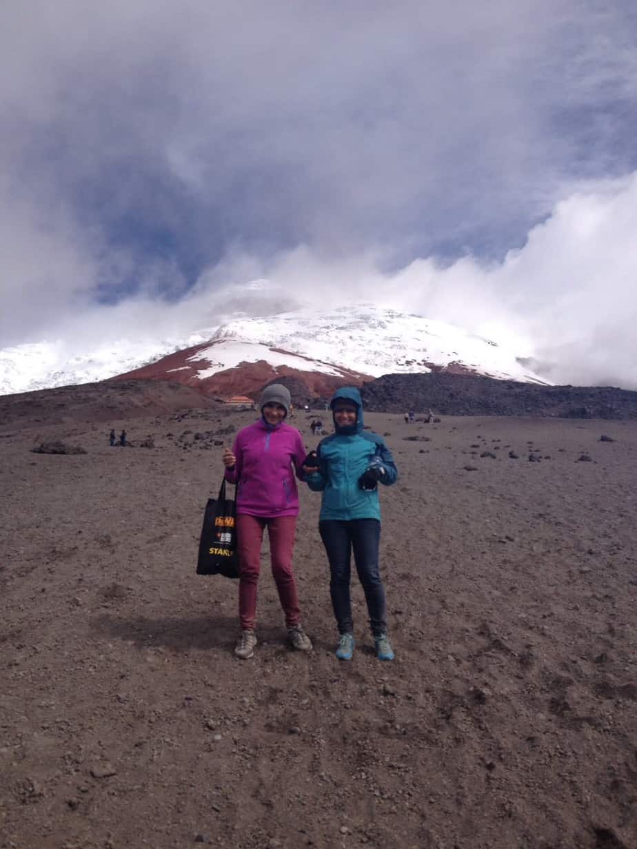
We had planned on visiting the imposing (5895m) Cotopaxi, long before we arrived in Equador, as it is the highest active volcano in the world and had been highly recommended. When it’s not shrouded in cloud,the snow covered peak is clearly visible from Quito 50km away.
We couldn’t believe our luck when Elsa asked if we fancied a trip with her to the National Park and a hike up to the refugio (4864m), as the logistics of bussing the 2 hour journey south from Quito and then hitching the remaining hour to the base of the volcano were proving to be a little difficult. Also, we didn’t want to spend (waste) money signing up for a tour, unless we were going to try for the summit (beyond the refugio) which means an overnight stay and use of ice-climbing gear.
We set off from Quito mid-morning and reached the National Park entrance just before midday. Shortly before this we had stopped in nearby Santa Rita as there were some guides offering their services US$70 (negotiable) to escort us to the refugio…when Elsa advised us that her pickup could handle the dirt road, we recommended not to use a guide (good decision).
After signing in, we entered Parque Nacional de Cotopaxi. It’s approx. 30km drive from the entrance (3200m) to the car park (4550m) )at the base of the climb. The first 10km is pretty uneventful as its on sealed road. The remaining 20km is increasingly interesting, as the dirt road and terrain become increasingly rough and steep, whilst the landscape becomes more impressive. Approximately half way to the car park is a diversion to a scenic lake (and optional walking circuit)…we decided to stop there on our return journey.
As we approached the car park the road started winding and the surface worsened. At one stage we ground to a halt behind a bottleneck of front wheel drive vehicles all struggling for traction. The 2 of us jumped out, stuck large stones under the rear wheels and gave the pickup a good shove whilst Elsa hit the accelerator.
 After an eventful final 30 minutes drive we reached the car park. At that stage the peak was covered in cloud, there was light rain and a fresh breeze and we questioned the logic of starting the hike up…but as we were on a high after the drive, we decided to carry on.
After propping the tyres with some large stones (we were on a steep slope) and putting on jackets we started the very slow walk up the remaining 300m or so towards the refuge. It was cold, into a fresh headwind, with light rain, and the terrain was very steep and scree-like; meaning that for every two steps forward there was at least a half step back.


The 3 of us took it slowly, stopping every 25m or so to catch a breath…but there was never any doubt that we would reach the refugio after we saw a boy of probably no more than 8 years of age coming in the opposite direction.
After what seemed like forever but was probably only an hour climbing, we reached the refugio.
We went inside for a well deserved hot drink before heading back down. When we came back out, we couldn’t believe our luck as the clouds had lifted enough to give us amazing views of the snow covered peak.


Heading back down we had to be careful as the terrain was very loose but we were all really happy with our afternoon’s work.

Reaching the car park, we looked back up at the mountain to admire the view, only to notice that approximately 100m to the left of where we had ascended was an obvious path, which was far less steep, with multiple switchbacks, leading up towards the refugio. We agreed that we had definitely taken the tougher route but all felt better for doing so.
The bumpy drive back down the mountain didn’t feel half as bad as it had on the way up (we noticed a few mountain bikes doing the descent from the car park) and the drive back to Quito was very sweet.
To sum up Cotopaxi…it’s a great day out and well worth the effort to get there, although we were lucky enough to have transport. Don’t bother with a tour/guide unless aiming for the summit (when it’s compulsory) and just enjoy the beauty of your surroundings.