After an incredible week in Mexico at the multiple weddings of our dear Adventure Gang amiga Angie and her new marido Luis, we thought we would top off our North American trip with a couple of days in Yosemite National Park, California.
We were super excited about the prospect of hiking to and climbing the iconic ‘Half-Dome’ (the default screensaver for half the world’s computers) but owing to the Californian leg of our trip being a bit of an afterthought, we had long since missed the deadline to apply for a permit to climb…It’s possible to hike all of the other wonderful trails in the park without a permit, indeed you can hike to the foot of Half-Dome without one but you wont be allowed to use ‘the cables’ which enable you to climb Half Dome itself.
Half Dome at sun set.
Fortunately we discovered that, if you apply online 2 days before your expected hike date, you can go into a draw for a small number of last minute permits. As we had planned 2 days in the park, we applied for Half Dome permits on both days under both our names to improve our chances. We had no luck on the first (our preferred) day but were lucky enough to bag cable permits for the second day (very lucky as it turned out because it was summer holidays and the park had been closed the previous 2 weeks due to nearby bushfires). The only problem was, with the hike and climb to Half-Dome projected to take between 10-12 hours return, and our flight from San Franscisco leaving at 8pm, with a 4-5 hour car journey between the two, we knew we would have to start hiking very early.
When preparing for a hike up Half Dome, most people take it easy the day before…Not us! Don’t get us wrong; we had intended to take a leisurely stroll up the Lake May trail. A serene 4km round trip starting at the 2655m elevation trailhead and ending at Lake May at 2825m. It’s a steady climb to the lake but nothing too strenuous. Arriving at the lake at around midday we were greeted by the most amazing sight. Save for 3 middle-aged ladies who had hiked up earlier than us and the odd chipmunk, we had the lake to ourselves. Jon couldn’t resist stripping off and striding in for a quick dip but even in mid summer the water still wasn’t warm enough for Vanessa’s liking. Just as well because immediately Jon got out we spotted the “No Swimming“ sign…Oops!
Lake May (Mt Hoffman in the distance)
So there we were at Lake May…’What to do next?’ we thought. Return back down the trail and rest before tomorrow’s climb or continue up the trail to Mt Hoffmann at 3305m elevation? Well, the ‘Hoff’ looked so inviting towering high above us and would only take another 3 or so hours return…Why not?
The hike up from the lake was incredible. The views got better and better as we passed above the tree line and ascended through arid scree landscape towards the peak. As it turned out, what we had seen from the lake was actually a false peak, with the real Mt Hoffman hiding approx. 1km further on. The last few hundred metres constituted more climbing than hiking, as we clambered over some pretty large rocks, with the odd Dusky for company.
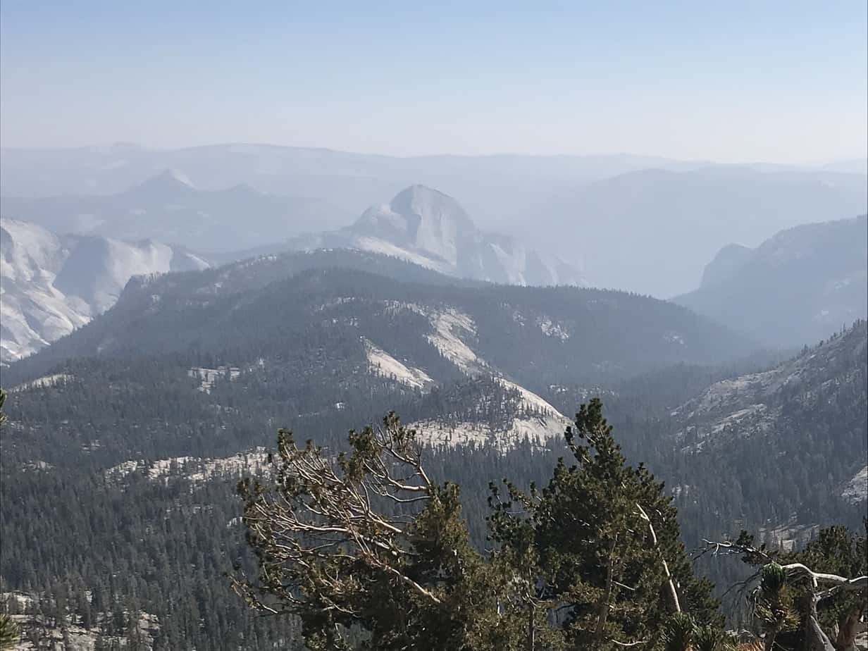
Reaching the peak we were rewarded with breathtaking views over the park and valley below.
View of Yosemite Valley from Mt Hoffman (Half Dome in the distance)Show offs
We stopped for a well earned lunch and headed back the same way as we had come, seeing only a handful of hikers along the route. Arriving back at the trailhead nearly 6 hours after we had started, we did question whether it was the ideal preparation but were both glad to have done it.
As it was the height of tourist season we had been unable to bag a camp site in Yosemite valley itself, which meant that we had a drive of around 45 minutes up from the valley floor to our campsite but we couldnt help but stop to take a snap or two as the setting sun hit the face of Half Dome.
The following morning we woke at 4am. and, after a very quick breakfast, drove back down into the valley. By 5am we had parked in the trailhead carpark. Despite the fact that it was still dark (the sun didn’t start to rise for another half hour so head torches were needed) there were a few other cars/hikers in the carpark but we set off immediately whilst they were getting their sh*t together. As we did, we promised each other that if we had not reached ‘the cables’ by 9.30am we would turn back as we needed to start the drive back to San Fran airport by no later than 2pm. As we walked along the trail through the valley in the darkness, Vanessa kept talking. She was anxious to make as much noise as possible to warn off any bears.
The route to Half Dome follows a small portion of the famous 340km long John Muir trail. It’s a steep climb but well marked and packed full of spectacular scenery. It’s only 11.3km to the base of Half Dome but at almost 1500m ascent from trailhead to peak its not easy.
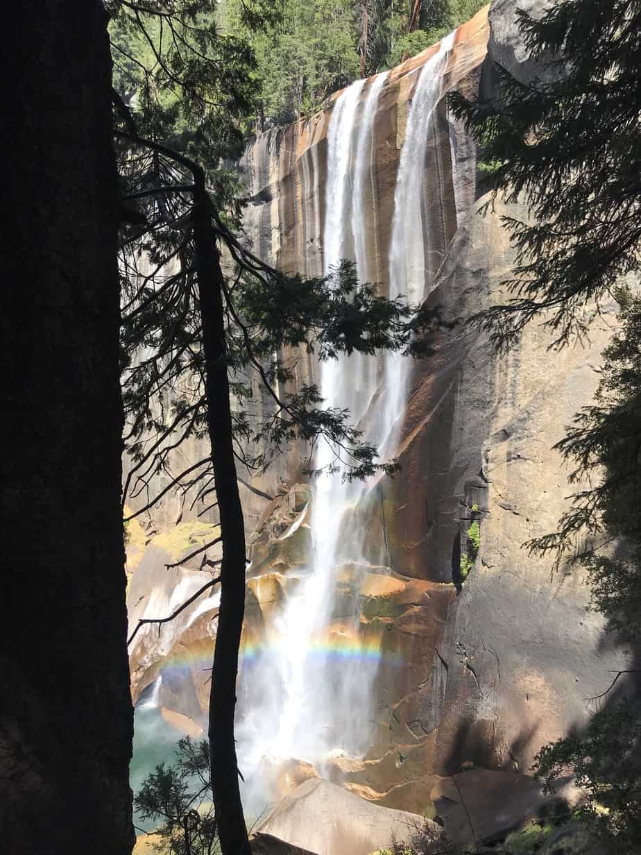
Starting early meant we had the trail more or less to ourselves for most of the climb. Immediately the sun started to rise, we were greeted by views of Vernal Falls, which looked beautiful although not in full flow due to the recent dry weather.
Vernal Falls
Further up the trail we passed the equally impressive Nevada Falls and shortly after that, we were treated to views of Liberty Cap, immediatley to the North of us.
Nevada FallsLiberty Cap
Passing through forrests of towering redwoods, we decided not to stop too long for fear of falling pinecones…Ouch!
The trail then leveled off for a short while and passed by Upper Pines campground. If you are super organised and book many months in advance (not us), you can secure one of the very limited overnight camping spots here. It sits approximately half way between the trailhead and Half Dome and means that you can beat the crowds up to the cables.
Another hour or so after Upper Pines the trees taper off and we found ourselves climbing Quarter Dome. This is essentially the steep rocky slope leading to the base of Half Dome.
From here we had great views of Mount Broderick and Liberty Cap (now off to the South of us). Shortly after, we caught our first view of the cables. There were already a small number of people climbing (those that had set off from Upper Pines). From where we stood, they looked like ants climbing a wall.
Human trail of ants climbing Half Dome
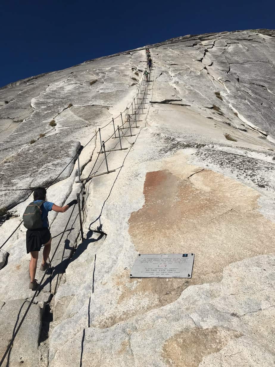
Reaching the base of the cables we took a few moments to take stock of what lay ahead. Infront of us was an immense wall of rock, seemingly with no end in sight. We also did a time check. It was only 8.30am, so we had made good time. Luckily there was a box of gloves at the base of the cables. Vanessa had been organised and brought her own gloves. Jon decided to borrow a pair for the climb. We set off up the cables, leaving a decent gap to those in front of us, as some people appeared to be labouring a little.
Here we go!
Not surprisingly, Jon enjoyed the cables immensely. Vanessa on the other hand, was somewhat more cautious, particularly when approaching an overhang or passing someone. It transpired that her gloves had next to no grip but this was fixed pretty soon as Jon was happy to hand his over.
The cables were hard work on the arms but slowly but surely we inched our way up towards the top. After around 15 minutes or so we reached the end of the cables. After catching our breath, it was time to high-five each other and take in what we had done. We then had some time to take some panoramic photos.
Mind your stepStanding at the top
We then sat down to eat our very early (it was only 9am) but well deserved lunch, which we shared with a squirrel who probably didn’t buy a permit for the cables.
Once our appetites were (temporarily) sated, we decided to head back down. For many, including Vanessa, the prospect of climbing back down the cables is more intimidating than the climb up. Initially Vanessa was hesitant but once she decided to decend facing backwards rather than forwards, things were a lot easier.
At the bottom of the cables we returned the borrowed gloves and headed on back the way we had come. Shortly afterwards we passed a park ranger who was belatedly checking for permits before allowing everyone to climb the cables. Some unfortunates were not permitted to continue.
What we also noticed was that, although it was not yet 10am, it was getting hot. We were glad we had completed the climb before the midday sun had hit, otherwise it would have made for a very tough day. On our way down, we passed some very weary hikers heading uphill. One, less-than-svelte, particularly sweaty looking gentlemen stopped us and asked where the next water stop was. When we explained that there were none in the direction he was heading, he looked concerned. We asked how much he had left and he showed us his last 100ml, which he promptly drank. Jon, known for his aversion to drinking water, took pity on the poor soul and emptied a litre of his water into the empty bottle. We parted ways with the grateful stranger, wishing him luck and secretly thinking that a litre would not be nearly enough!
As we descended closer to Yosemite valley the number of people on the track ramped up due to many people taking the relatively short walk up to see the waterfalls. This meant that it was slow going as we tried to pick our way past the masses, all the while aware of the need to head back to San Fran and catch our 8pm flight. We arrived back at the car at 1pm. An hour earlier than our deadline. It had taken 8 hours but we had not spared the horses.
From there, we had a somewhat stressful 5 hour drive back to the airport, during which we got caught in some very long tailbacks but managed to get there shortly after 6pm. Ironically, our flight was delayed by 3 hours…If only we had known beforehand! Anyway, in summary, if you ever get a chance to visit Yosemite, no matter if it’s only for a day or two…grab it with both hands…you won’t regret it.